


KELP - El Paso Intl
Located in El Paso, United States
ICAO - ELP, IATA - ELP
Data provided by AirmateGeneral information
Coordinates: N31°48'26" W106°22'35"
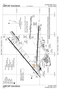
Elevation is 3961 feet MSL.
Magnetic variation is 08° East View others Airports in Texas
Operational data
Special qualification required
Current time UTC:
Current local time:
Weather
METAR: KELP 122051Z 25023G32KT 10SM FEW120 28/M09 A2986 RMK AO2 PK WND 27034/1952 SLP037 T02831094 56018
TAF: KELP 121720Z 1218/1318 27015G25KT P6SM SKC FM130300 30008KT P6SM FEW120
Communications frequencies: [VIEW]
Runways:
| RWY identifier | QFU | Length (ft) | Width (ft) | Surface | LDA (ft) |
| 04 | 50° | 12020 | 150 | OTHER | 12020 |
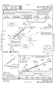
| 22 | 230° | 12020 | 150 | OTHER | 12020 |
| 08L | 93° | 5499 | 75 | CONC | 5499 |
| 26R | 273° | 5499 | 75 | CONC | 5499 |
| 08R | 93° | 9025 | 150 | OTHER | 9025 |
| 26L | 273° | 9025 | 150 | OTHER | 9025 |
Airport contact information
Address: El Paso United States
Other aviation service providers
Flight schools

Joe's Flight School And Aviation Services
Joe's Flight School And Aviation Services
joesflightschool@gmail.com+1(915)781-7733