


KEAT - Pangborn Meml
Located in Wenatchee, United States
ICAO - EAT, IATA - EAT
Data provided by AirmateGeneral information
Coordinates: N47°23'56" W120°12'25"
Elevation is 1248 feet MSL.
Magnetic variation is 15° East View others Airports in Washington
Operational data
Special qualification required
Current time UTC:
Current local time:
Weather
METAR: KEAT 281055Z AUTO 32008KT 10SM CLR 14/07 A2994 RMK AO2 SLP134 T01440072
TAF: KEAT 280520Z 2806/2906 30005KT P6SM BKN200 FM281600 30007KT P6SM FEW070 BKN150 FM281900 28010KT P6SM SCT070 BKN120 FM282100 29013G20KT P6SM FEW070 SCT120 BKN200 FM290000 29020G27KT P6SM FEW070 SCT120 FM290300 29017G24KT P6SM SKC
Communications frequencies: [VIEW]
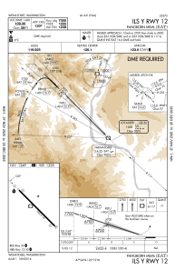
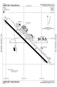
Runways:
| RWY identifier | QFU | Length (ft) | Width (ft) | Surface | LDA (ft) |
| 12 | 135° | 7000 | 150 | ASPH | 7000 |
| 30 | 315° | 7000 | 150 | ASPH | 7000 |
Airport contact information
Address: Wenatchee United States
