


KDTO - Denton Enterprise
Located in Denton, United States
ICAO - DTO, IATA -
Data provided by AirmateGeneral information
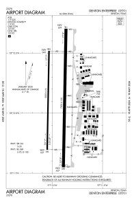
Coordinates: N33°12'7" W97°11'57"
Elevation is 642 feet MSL.
Magnetic variation is 04° East View others Airports in Texas
Operational data
Special qualification required
Current time UTC:
Current local time:
Weather
METAR: KDTO 271753Z 16017G29KT 10SM SCT036 BKN050 26/20 A2980 RMK AO2 PK WND 17031/1717 SLP082 T02610200 10267 20228 58008
Communications frequencies: [VIEW]
Runways:
| RWY identifier | QFU | Length (ft) | Width (ft) | Surface | LDA (ft) |
| 18L | 181° | 7002 | 150 | ASPH | 6502 |
| 36R | 1° | 7002 | 150 | ASPH | 6502 |
| 18R | 181° | 5003 | 75 | ASPH | |
| 36L | 1° | 5003 | 75 | ASPH |
Airport contact information
Address: Denton United States

