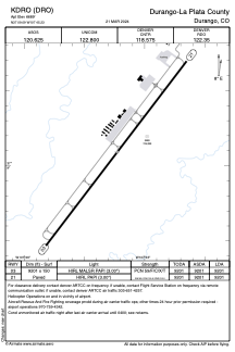


KDRO - Durango-La Plata County
Located in Durango, United States
ICAO - DRO, IATA - DRO
Data provided by AirmateGeneral information
Coordinates: N37°9'6" W107°45'14"
Elevation is 6689 feet MSL.
Magnetic variation is 10° East View others Airports in Colorado
Operational data
Special qualification required
Current time UTC:
Current local time:
Weather
METAR: KDRO 270853Z AUTO 11005KT 10SM BKN003 OVC022 02/ A2977 RMK AO2 RAE18 SLP059 P0000 60017 T0017 55005 $
TAF: KDRO 270524Z 2706/2806 28005KT 6SM -RA BR SCT020 OVC035 FM270900 16007KT 6SM -SHRA BR OVC015 FM271000 16007KT 6SM -SHRA BR OVC020 FM271500 18008KT 6SM -SHRASN BR BKN020 FM271900 24008KT 6SM BR VCTS SCT030CB BKN035 FM272100 25011KT P6SM VCTS SCT035CB BKN040
Communications frequencies: [VIEW]
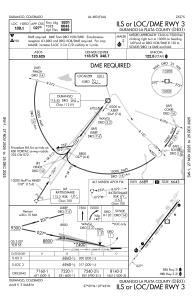
Runways:
| RWY identifier | QFU | Length (ft) | Width (ft) | Surface | LDA (ft) |
| 03 | 37° | 9201 | 150 | ASPH | 9201 |
| 21 | 217° | 9201 | 150 | ASPH | 9201 |
Airport contact information
Address: Durango United States