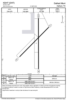


KDHT - Dalhart Muni
Located in Dalhart, United States
ICAO - DHT, IATA - DHT
Data provided by AirmateGeneral information
Coordinates: N36°1'21" W102°32'51"
Elevation is 3991 feet MSL.
Magnetic variation is 09° East View others Airports in Texas
Operational data
Special qualification required
Current time UTC:
Current local time:
Weather
METAR: KDHT 150553Z AUTO 18005KT 10SM FEW120 18/06 A2984 RMK AO2 SLP046 T01830056 10289 20183 403110078 50010
TAF: KDHT 150534Z 1506/1606 30009KT P6SM SCT190 FM151800 36009KT P6SM FEW250 FM152100 07012KT P6SM SCT230 PROB30 1521/1603 4SM TSRA BR BKN230CB FM160300 05009KT P6SM BKN110 PROB30 1603/1606 4SM TSRA BR OVC025CB
Communications frequencies: [VIEW]
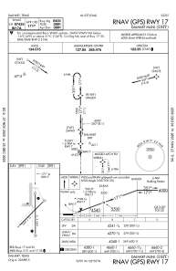
Runways:
| RWY identifier | QFU | Length (ft) | Width (ft) | Surface | LDA (ft) |
| 03 | 45° | 5440 | 75 | ASPH | |
| 21 | 225° | 5440 | 75 | ASPH | |
| 17 | 180° | 6400 | 75 | ASPH | |
| 35 | 360° | 6400 | 75 | ASPH |
Airport contact information
Address: Dalhart United States