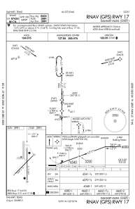
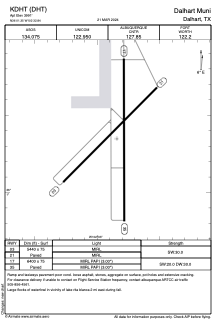


KDHT - Dalhart Muni
Located in Dalhart, United States
ICAO - DHT, IATA - DHT
Data provided by AirmateGeneral information
Coordinates: N36°1'21" W102°32'51"
Elevation is 3991 feet MSL.
Magnetic variation is 09° East View others Airports in Texas
Operational data
Special qualification required
Current time UTC:
Current local time:
Weather
METAR: KDHT 021653Z AUTO 02022G30KT 10SM FEW039 19/04 A2995 RMK AO2 PK WND 36032/1601 SLP094 T01940039
TAF: KDHT 021120Z 0212/0312 02023G33KT P6SM SCT250 FM022200 08014KT P6SM SCT250
Communications frequencies: [VIEW]
Runways:
| RWY identifier | QFU | Length (ft) | Width (ft) | Surface | LDA (ft) |
| 03 | 45° | 5440 | 75 | ASPH | |
| 21 | 225° | 5440 | 75 | ASPH | |
| 17 | 180° | 6400 | 75 | ASPH | |
| 35 | 360° | 6400 | 75 | ASPH |
Airport contact information
Address: Dalhart United States