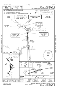
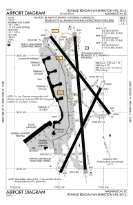


KDCA - Ronald Reagan Washington Ntl
Located in Washington, United States
ICAO - DCA, IATA - DCA
Data provided by AirmateGeneral information
Coordinates: N38°51'5" W77°2'16"
Elevation is 14 feet MSL.
Magnetic variation is -11° East View others Airports in District of Columbia
Operational data
Special qualification required
Current time UTC:
Current local time:
Weather
METAR: KDCA 282352Z 19008KT 10SM FEW040 SCT250 24/16 A3005 RMK AO2 SLP176 T02390156 10289 20239 56008
TAF: KDCA 282320Z 2900/3006 18004KT P6SM FEW050 SCT250 FM290200 20006KT P6SM FEW250 FM290800 21004KT P6SM SKC FM291400 15005KT P6SM SCT250 FM291800 22005KT P6SM FEW050 FEW250 FM292000 19006KT P6SM FEW050 SCT250
Communications frequencies: [VIEW]
Runways:
| RWY identifier | QFU | Length (ft) | Width (ft) | Surface | LDA (ft) |
| 01 | 356° | 7169 | 150 | ASPH | 6869 |
| 19 | 175° | 7169 | 150 | ASPH | 6869 |
| 04 | 26° | 5000 | 150 | ASPH | 4800 |
| 22 | 206° | 5000 | 150 | ASPH | 4400 |
| 15 | 143° | 5204 | 150 | ASPH | 5204 |
| 33 | 323° | 5204 | 150 | ASPH | 5204 |
Airport contact information
Address: Washington United States