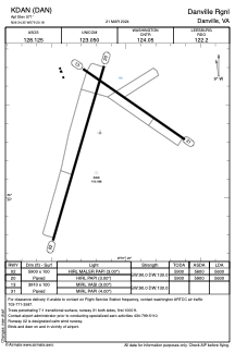


KDAN - Danville Rgnl
Located in Danville, United States
ICAO - DAN, IATA - DAN
Data provided by AirmateGeneral information
Coordinates: N36°34'21" W79°20'11"
Elevation is 571 feet MSL.
Magnetic variation is -09° East View others Airports in Virginia
Operational data
Special qualification required
Current time UTC:
Current local time:
Weather
METAR: KDAN 291753Z AUTO 22007G15KT 170V270 10SM CLR 27/13 A3009 RMK AO2 SLP179 T02670133 10267 20178 58018
TAF: KDAN 291722Z 2918/3018 23009KT P6SM SKC FM292200 21008KT P6SM SKC FM301200 23007KT P6SM SCT220 FM301700 22010G18KT P6SM BKN170
Communications frequencies: [VIEW]
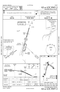
Runways:
| RWY identifier | QFU | Length (ft) | Width (ft) | Surface | LDA (ft) |
| 02 | 16° | 5900 | 100 | ASPH | 5600 |
| 20 | 196° | 5900 | 100 | ASPH | 5600 |
| 13 | 125° | 3910 | 100 | ASPH | |
| 31 | 305° | 3910 | 100 | ASPH |
Airport contact information
Address: Danville United States
