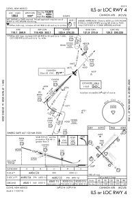
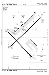


KCVS - Cannon Afb
Located in Clovis, United States
ICAO - CVS, IATA - CVS
Data provided by AirmateGeneral information
Coordinates: N34°22'58" W103°19'20"
Elevation is 4295 feet MSL.
Magnetic variation is 07° East View others Airports in New Mexico
Operational data
Special qualification required
Current time UTC:
Current local time:
Weather
METAR: KCVS 012355Z 23017KT 10SM CLR 31/M11 A2965 RMK AO2A PK WND 22029/14 SLP978 T03101108 10323 20285 57025 $
TAF: TAF KCVS 011800Z 0118/0224 27010G15KT 9999 SKC QNH2977INS BECMG 0119/0120 23015G25KT 9999 SKC QNH2966INS BECMG 0200/0201 20012KT 9999 SKC QNH2966INS TEMPO 0203/0205 18020G30KT BECMG 0207/0208 27012KT 9999 SKC QNH2973INS BECMG 0213/0214 35012G25KT 9999 SKC QNH2986INS BECMG 0217/0218 VRB06KT 9999 FEW100 QNH2975INS TX31/0122Z TN14/0212Z
Communications frequencies: [VIEW]
Runways:
| RWY identifier | QFU | Length (ft) | Width (ft) | Surface | LDA (ft) |
| 04 | 45° | 10003 | 150 | CONC | |
| 22 | 225° | 10003 | 150 | CONC | |
| 13 | 135° | 8196 | 150 | OTHER | |
| 31 | 315° | 8196 | 150 | OTHER |
Airport contact information
Address: Clovis United States