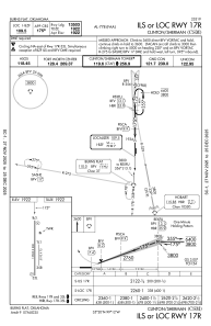
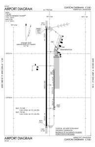


KCSM - Clinton/Sherman
Located in Burns Flat, United States
ICAO - CSM, IATA - CSM
Data provided by AirmateGeneral information
Coordinates: N35°20'23" W99°12'2"
Elevation is 1922 feet MSL.
Magnetic variation is 05° East View others Airports in Oklahoma
Operational data
Special qualification required
Current time UTC:
Current local time:
Weather
METAR: KCSM 091253Z AUTO 35009KT 10SM BKN090 13/06 A2992 RMK AO2 SLP117 T01280061
TAF: KCSM 091120Z 0912/1012 02008KT P6SM SKC FM091400 04016G24KT P6SM BKN080 FM100200 02008KT P6SM FEW100
Communications frequencies: [VIEW]
Runways:
| RWY identifier | QFU | Length (ft) | Width (ft) | Surface | LDA (ft) |
| 17L | 180° | 5193 | 75 | CONC | |
| 35R | 0° | 5193 | 75 | CONC | |
| 17R | 180° | 13503 | 200 | CONC | |
| 35L | 0° | 13503 | 200 | CONC |
Airport contact information
Address: Burns Flat United States