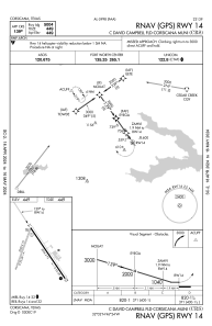
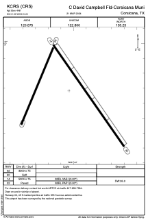


KCRS - C David Campbell Fld-Corsicana Muni
Located in Corsicana, United States
ICAO - CRS, IATA - CRS
Data provided by AirmateGeneral information
Coordinates: N32°1'41" W96°24'2"
Elevation is 448 feet MSL.
Magnetic variation is 06° East View others Airports in Texas
Operational data
Special qualification required
Current time UTC:
Current local time:
Weather
METAR: KCRS 281753Z AUTO 13012KT 10SM FEW009 SCT037 BKN110 22/20 A2985 RMK AO2 PK WND 13032/1654 RAE52 SLP103 P0000 60058 T02220200 10239 20194 51007
Communications frequencies: [VIEW]
Runways:
| RWY identifier | QFU | Length (ft) | Width (ft) | Surface | LDA (ft) |
| 02 | 22° | 3200 | 75 | GRASS | |
| 20 | 202° | 3200 | 75 | GRASS | |
| 14 | 145° | 5004 | 75 | ASPH | |
| 32 | 325° | 5004 | 75 | ASPH |
Airport contact information
Address: Corsicana United States