


KCRP - Corpus Christi Intl
Located in Corpus Christi, United States
ICAO - CRP, IATA - CRP
Data provided by AirmateGeneral information
Coordinates: N27°46'20" W97°30'9"
Elevation is 46 feet MSL.
Magnetic variation is 04° East View others Airports in Texas
Operational data
Special qualification required
Current time UTC:
Current local time:
Weather
METAR: KCRP 280351Z 14015G24KT 9SM SCT013 BKN017 OVC024 26/24 A2979 RMK AO2 PK WND 15030/0254 SLP085 T02560239
TAF: KCRP 272321Z 2800/2824 15022G30KT P6SM BKN017 OVC024 FM280300 15019G26KT P6SM OVC015 FM281600 16014KT P6SM VCSH SCT016 BKN025 PROB30 2818/2822 -TSRA OVC012CB
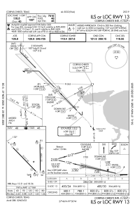
Communications frequencies: [VIEW]
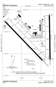
Runways:
| RWY identifier | QFU | Length (ft) | Width (ft) | Surface | LDA (ft) |
| 13 | 136° | 7510 | 150 | ASPH | 7510 |
| 31 | 316° | 7510 | 150 | ASPH | 7510 |
| 18 | 179° | 6080 | 150 | ASPH | 6080 |
| 36 | 359° | 6080 | 150 | ASPH | 6080 |
Airport contact information
Address: Corpus Christi United States