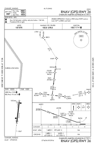
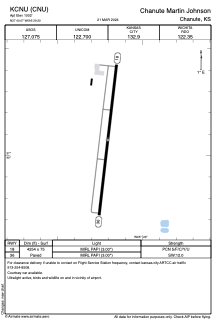


KCNU - Chanute Martin Johnson
Located in Chanute, United States
ICAO - CNU, IATA - CNU
Data provided by AirmateGeneral information
Coordinates: N37°40'4" W95°29'12"
Elevation is 1002 feet MSL.
Magnetic variation is 05° East View others Airports in Kansas
Operational data
Special qualification required
Current time UTC:
Current local time:
Weather
METAR: KCNU 250852Z AUTO 04004KT 10SM CLR 15/11 A2989 RMK AO2 SLP111 T01500106 50006
TAF: KCNU 250535Z 2506/2606 VRB03KT P6SM FEW250 FM251500 12008KT P6SM FEW250 FM252100 16011KT P6SM FEW140 PROB30 2603/2606 VRB30G45KT 2SM TSRA BR BKN030CB
Communications frequencies: [VIEW]
Runways:
| RWY identifier | QFU | Length (ft) | Width (ft) | Surface | LDA (ft) |
| 18 | 187° | 4254 | 75 | ASPH | |
| 36 | 7° | 4254 | 75 | ASPH |
Airport contact information
Address: Chanute United States