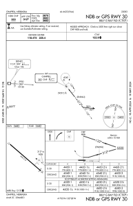
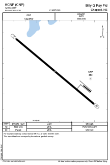


KCNP - Billy G Ray Fld
Located in Chappell, United States
ICAO - CNP, IATA -
Data provided by AirmateGeneral information
Coordinates: N41°4'39" W102°27'51"
Elevation is 3681 feet MSL.
Magnetic variation is 10° East View others Airports in Nebraska
Operational data
Special qualification required
Current time UTC:
Current local time:
Weather at : KSNY - Sidney Muni/Lloyd W Carr Fld ( 44 km )
METAR: KSNY 100953Z AUTO 30011KT 10SM CLR 04/02 A3027 RMK AO2 SLP242 T00440017
TAF: KSNY 100520Z 1006/1106 33010KT P6SM OVC070 FM101200 32010KT P6SM OVC050 FM101800 35010KT P6SM BKN080 FM110200 08006KT P6SM SCT150
Communications frequencies: [VIEW]
Runways:
| RWY identifier | QFU | Length (ft) | Width (ft) | Surface | LDA (ft) |
| 12 | 130° | 4000 | 55 | ASPH | |
| 30 | 310° | 4000 | 55 | ASPH |
Airport contact information
Address: Chappell United States