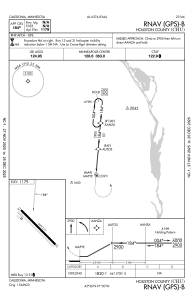
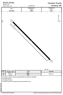


KCHU - Houston County
Located in Caledonia, United States
ICAO - CHU, IATA -
Data provided by AirmateGeneral information
Coordinates: N43°35'47" W91°30'14"
Elevation is 1179 feet MSL.
Magnetic variation is 01° East View others Airports in Minnesota
Operational data
Special qualification required
Current time UTC:
Current local time:
Weather at : KLSE - La Crosse Rgnl ( 37 km )
METAR: KLSE 132053Z 31005KT 5SM HZ CLR 24/05 A2974 RMK AO2 SLP064 T02390050 56011
TAF: KLSE 131723Z 1318/1418 30009KT 4SM HZ OVC250 FM140600 05007KT P6SM SCT250
Communications frequencies: [VIEW]
Runways:
| RWY identifier | QFU | Length (ft) | Width (ft) | Surface | LDA (ft) |
| 13 | 135° | 3499 | 77 | ASPH | |
| 31 | 315° | 3499 | 77 | ASPH |
Airport contact information
Address: Caledonia United States