


KCDC - Cedar City Rgnl
Located in Cedar City, United States
ICAO - CDC, IATA - CDC
Data provided by AirmateGeneral information
Coordinates: N37°42'3" W113°5'56"
Elevation is 5622 feet MSL.
Magnetic variation is 14° East View others Airports in Utah
Operational data
Special qualification required
Current time UTC:
Current local time:
Weather
METAR: KCDC 181853Z AUTO 23011G21KT 10SM CLR 26/M01 A3002 RMK AO2 SLP086 T02611006
TAF: KCDC 181739Z 1818/1918 24015G24KT P6SM SCT120 BKN250 FM190300 20007KT P6SM FEW120 SCT250 FM191200 19005KT P6SM SKC FM191700 24016G25KT P6SM FEW250
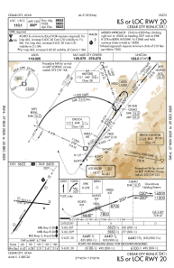
Communications frequencies: [VIEW]
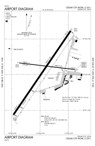
Runways:
| RWY identifier | QFU | Length (ft) | Width (ft) | Surface | LDA (ft) |
| 02 | 34° | 8653 | 150 | ASPH | 8653 |
| 20 | 214° | 8653 | 150 | ASPH | 8653 |
| 08 | 97° | 4822 | 60 | ASPH | 4822 |
| 26 | 277° | 4822 | 60 | ASPH | 4822 |
Airport contact information
Address: Cedar City United States
