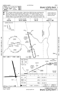
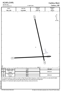


KCAR - Caribou Muni
Located in Caribou, United States
ICAO - CAR, IATA - CAR
Data provided by AirmateGeneral information
Coordinates: N46°52'18" W68°1'5"
Elevation is 620 feet MSL.
Magnetic variation is -17° East View others Airports in Maine
Operational data
Special qualification required
Current time UTC:
Current local time:
Weather
TAF: KCAR 271120Z 2712/2812 VRB03KT P6SM SKC FM272100 15004KT P6SM FEW250 FM281000 16007KT P6SM BKN250
Communications frequencies: [VIEW]
Runways:
| RWY identifier | QFU | Length (ft) | Width (ft) | Surface | LDA (ft) |
| 01 | 347° | 4003 | 100 | ASPH | |
| 19 | 167° | 4003 | 100 | ASPH | |
| 11 | 88° | 3016 | 75 | ASPH | |
| 29 | 268° | 3016 | 75 | ASPH |
Airport contact information
Address: Caribou United States