


KCAO - Clayton Muni Airpark
Located in Clayton, United States
ICAO - CAO, IATA - CAO
Data provided by AirmateGeneral information
Coordinates: N36°26'47" W103°8'60"
Elevation is 4969 feet MSL.
Magnetic variation is 09° East View others Airports in New Mexico
Operational data
Special qualification required
Current time UTC:
Current local time:
Weather
METAR: KCAO 272055Z AUTO 22025G38KT 10SM CLR 19/M09 A2969 RMK AO2 PK WND 20047/2021 SLP009 T01941094 55004 $
Communications frequencies: [VIEW]
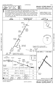
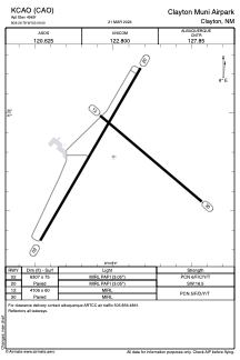
Runways:
| RWY identifier | QFU | Length (ft) | Width (ft) | Surface | LDA (ft) |
| 02 | 30° | 6307 | 75 | ASPH | |
| 20 | 210° | 6307 | 75 | ASPH | |
| 12 | 130° | 4106 | 60 | ASPH | |
| 30 | 310° | 4106 | 60 | ASPH |
Airport contact information
Address: Clayton United States