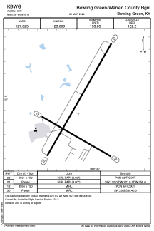


KBWG - Bowling Green-Warren County Rgnl
Located in Bowling Green, United States
ICAO - BWG, IATA - BWG
Data provided by AirmateGeneral information
Coordinates: N36°57'52" W86°25'11"
Elevation is 547 feet MSL.
Magnetic variation is -04° East View others Airports in Kentucky
Operational data
Special qualification required
Current time UTC:
Current local time:
Weather
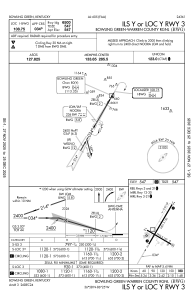
METAR: KBWG 162353Z AUTO 12004KT 10SM CLR 24/17 A2984 RMK AO2 SLP100 T02440172 10272 20239 56012
TAF: KBWG 162331Z 1700/1724 VRB04KT P6SM FEW050 BKN120 FM171200 VRB04KT P6SM -SHRA OVC070 FM171600 11006KT 6SM -SHRA SCT015 OVC025 PROB30 1716/1722 3SM -TSRA BKN025CB
Communications frequencies: [VIEW]
Runways:
| RWY identifier | QFU | Length (ft) | Width (ft) | Surface | LDA (ft) |
| 03 | 30° | 6501 | 150 | ASPH | |
| 21 | 210° | 6501 | 150 | ASPH | |
| 12 | 120° | 3956 | 150 | ASPH | |
| 30 | 300° | 3956 | 150 | ASPH |
Airport contact information
Address: Bowling Green United States
