


KBRD - Brainerd Lakes Rgnl
Located in Brainerd, United States
ICAO - BRD, IATA - BRD
Data provided by AirmateGeneral information
Coordinates: N46°24'15" W94°8'2"
Elevation is 1232 feet MSL.
Magnetic variation is 03° East View others Airports in Minnesota
Operational data
Special qualification required
Current time UTC:
Current local time:
Weather
METAR: KBRD 030553Z AUTO 20007KT 10SM CLR 07/06 A2980 RMK AO2 SLP098 60004 T00720056 10094 20072 401060072 56009
TAF: KBRD 030538Z 0306/0406 19008KT P6SM SKC FM030800 21008KT P6SM SKC WS020/25038KT FM031200 23012G21KT P6SM SKC FM032100 24014G20KT P6SM BKN100 FM040000 25012KT 6SM -SHRA OVC050
Communications frequencies: [VIEW]
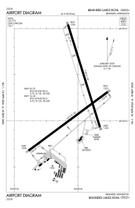
Runways:
| RWY identifier | QFU | Length (ft) | Width (ft) | Surface | LDA (ft) |
| 05 | 54° | 6512 | 150 | CONC | |
| 23 | 234° | 6512 | 150 | CONC | |
| 16 | 163° | 7100 | 150 | CONC | |
| 34 | 343° | 7100 | 150 | CONC |
Airport contact information
Address: Brainerd United States
