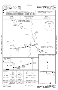
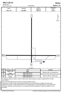


KBLH - Blythe
Located in Blythe, United States
ICAO - BLH, IATA - BLH
Data provided by AirmateGeneral information
Coordinates: N33°37'9" W114°43'1"
Elevation is 399 feet MSL.
Magnetic variation is 13° East View others Airports in California
Operational data
Special qualification required
Current time UTC:
Current local time:
Weather
METAR: KBLH 020252Z AUTO 18006KT 10SM CLR 30/06 A2966 RMK AO2 SLP039 T03000056 53007
TAF: KBLH 012320Z 0200/0224 19007KT P6SM SKC FM021100 VRB04KT P6SM SKC FM021700 17010KT P6SM SKC
Communications frequencies: [VIEW]
Runways:
| RWY identifier | QFU | Length (ft) | Width (ft) | Surface | LDA (ft) |
| 08 | 90° | 6543 | 150 | ASPH | |
| 26 | 270° | 6543 | 150 | ASPH | |
| 17 | 180° | 5800 | 100 | ASPH | |
| 35 | 0° | 5800 | 100 | ASPH |
Airport contact information
Address: Blythe United States