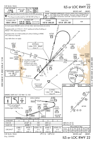
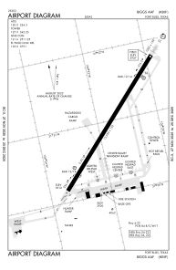


KBIF - Biggs Aaf (Fort Bliss)
Located in Fort Bliss/El Paso/, United States
ICAO - BIF, IATA - BIF
Data provided by AirmateGeneral information
Coordinates: N31°50'58" W106°22'48"
Elevation is 3946 feet MSL.
Magnetic variation is 08° East View others Airports in Texas
Operational data
Special qualification required
Current time UTC:
Current local time:
Weather
METAR: KBIF 280055Z 28014G23KT 7SM FEW120 21/M08 A2987 RMK AO2A PK WND 31026/2357 SLP041 ALSTG/SLP ESTMD WND DATA ESTMD T02081083 $
TAF: TAF AMD KBIF 272050Z 2720/2901 26025G35KT 4800 BLDU BKN100 611206 530009 QNH2978INS BECMG 2800/2801 28015G25KT 9999 NSW SKC 520006 QNH2981INS BECMG 2805/2806 30010G15KT 9999 SKC QNH2988INS TX22/2723Z TN09/2812Z
Communications frequencies: [VIEW]
Runways:
| RWY identifier | QFU | Length (ft) | Width (ft) | Surface | LDA (ft) |
| 04 | 44° | 13554 | 150 | CONC | |
| 22 | 224° | 13554 | 150 | CONC |
Airport contact information
Address: Fort Bliss/El Paso/ United States