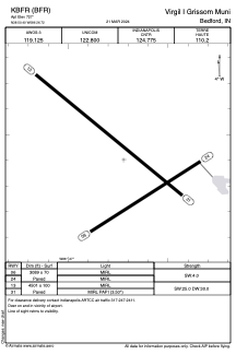


KBFR - Virgil I Grissom Muni
Located in Bedford, United States
ICAO - BFR, IATA - BFR
Data provided by AirmateGeneral information
Coordinates: N38°50'24" W86°26'43"
Elevation is 727 feet MSL.
Magnetic variation is -04° East View others Airports in Indiana
Operational data
Special qualification required
Current time UTC:
Current local time:
Weather at : KBMG - Monroe County ( 37 km )
METAR: KBMG 110453Z AUTO 23006KT 10SM CLR 13/09 A2988 RMK AO2 SLP114 T01330094 402110100
TAF: KBMG 110520Z 1106/1206 21005KT P6SM SCT210 FM110900 22008KT P6SM BKN060 FM111400 29010KT P6SM FEW240 FM111800 31013G20KT P6SM FEW250 FM120000 30008KT P6SM FEW220
Communications frequencies: [VIEW]
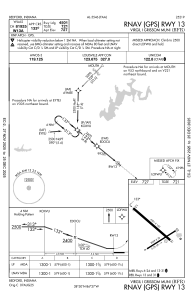
Runways:
| RWY identifier | QFU | Length (ft) | Width (ft) | Surface | LDA (ft) |
| 06 | 58° | 3089 | 70 | CONC | |
| 24 | 238° | 3089 | 70 | CONC | |
| 13 | 129° | 4501 | 100 | CONC | |
| 31 | 309° | 4501 | 100 | CONC |
Airport contact information
Address: Bedford United States
