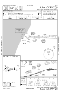
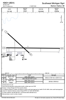


KBEH - Southwest Michigan Rgnl
Located in Benton Harbor, United States
ICAO - BEH, IATA - BEH
Data provided by AirmateGeneral information
Coordinates: N42°7'42" W86°25'30"
Elevation is 649 feet MSL.
Magnetic variation is -04° East View others Airports in Michigan
Operational data
Special qualification required
Current time UTC:
Current local time:
Weather
METAR: KBEH 272353Z AUTO 20011G22KT 10SM CLR 24/17 A2993 RMK AO2 PK WND 19027/2311 SLP132 T02390167 10272 20239 51007
Communications frequencies: [VIEW]
Runways:
| RWY identifier | QFU | Length (ft) | Width (ft) | Surface | LDA (ft) |
| 14 | 132° | 3205 | 60 | ASPH | |
| 32 | 312° | 3205 | 60 | ASPH | |
| 10 | 90° | 6006 | 100 | ASPH | |
| 28 | 270° | 6006 | 100 | ASPH |
Airport contact information
Address: Benton Harbor United States
