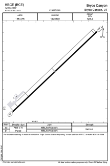


KBCE - Bryce Canyon
Located in Bryce Canyon, United States
ICAO - BCE, IATA - BCE
Data provided by AirmateGeneral information
Coordinates: N37°42'23" W112°8'45"
Elevation is 7590 feet MSL.
Magnetic variation is 14° East View others Airports in Utah
Operational data
Special qualification required
Current time UTC:
Current local time:
Weather
METAR: KBCE 060023Z AUTO 32015G25KT 1SM -SN BR VV017 M02/M03 A2974 RMK AO2 PK WND 31028/0012 P0000 T10171033
TAF: KBCE 052356Z 0600/0624 30018G28KT 1/2SM SN OVC010 FM060200 30010G20KT P6SM VCSH SCT020 BKN100 TEMPO 0604/0608 30018G28KT FM060800 30015G25KT 4SM -SN BR OVC008 FM061300 30012G22KT P6SM SCT012 SCT020
Communications frequencies: [VIEW]
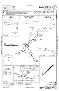
Runways:
| RWY identifier | QFU | Length (ft) | Width (ft) | Surface | LDA (ft) |
| 03 | 47° | 7395 | 75 | ASPH | |
| 21 | 227° | 7395 | 75 | ASPH |
Airport contact information
Address: Bryce Canyon United States