


KBAF - Westfield-Barnes Rgnl
Located in Westfield/Springfield, United States
ICAO - BAF, IATA - BAF
Data provided by AirmateGeneral information
Coordinates: N42°9'29" W72°42'57"
Elevation is 270 feet MSL.
Magnetic variation is -14° East View others Airports in Massachusetts
Operational data
Special qualification required
Current time UTC:
Current local time:
Weather
METAR: KBAF 271453Z 15008KT 10SM CLR 14/01 A3049 RMK AO2 SLP326 T01390006 58012
TAF: KBAF 271120Z 2712/2812 18004KT P6SM SKC FM271700 19007KT P6SM FEW250 FM280400 19007KT P6SM VCSH BKN030 FM280600 19006KT P6SM VCSH BKN010 FM281100 19005KT P6SM BKN008
Communications frequencies: [VIEW]
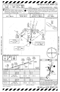
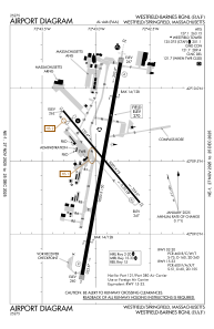
Runways:
| RWY identifier | QFU | Length (ft) | Width (ft) | Surface | LDA (ft) |
| 02 | 10° | 9000 | 150 | ASPH | 9000 |
| 20 | 190° | 9000 | 150 | ASPH | 8919 |
| 15 | 140° | 5000 | 75 | ASPH | 4510 |
| 33 | 320° | 5000 | 75 | ASPH | 5000 |
Airport contact information
Address: Westfield/Springfield United States

