


KART - Watertown Intl
Located in Watertown, United States
ICAO - ART, IATA - ART
Data provided by AirmateGeneral information
Coordinates: N43°59'31" W76°1'10"
Elevation is 330 feet MSL.
Magnetic variation is -12° East View others Airports in New York
Operational data
Special qualification required
Current time UTC:
Current local time:
Weather
METAR: KART 272156Z AUTO 18006G15KT 10SM -RA OVC044 14/04 A3017 RMK AO2 RAB50 SLP215 P0000 T01390039
TAF: KART 271745Z 2718/2818 18010G18KT 6SM -RA SCT050 BKN090 FM272000 18012G22KT 6SM -RA OVC050 FM280000 18012G22KT P6SM VCSH OVC025 FM280800 18012KT P6SM BKN050 FM281200 20012KT P6SM BKN015
Communications frequencies: [VIEW]
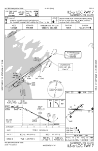
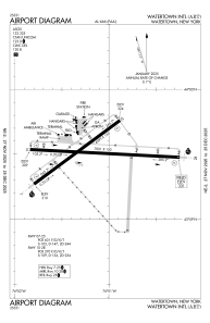
Runways:
| RWY identifier | QFU | Length (ft) | Width (ft) | Surface | LDA (ft) |
| 07 | 53° | 4999 | 150 | ASPH | 4784 |
| 25 | 233° | 4999 | 150 | ASPH | 4999 |
| 10 | 93° | 7001 | 150 | ASPH | 7001 |
| 28 | 273° | 7001 | 150 | ASPH | 7001 |
Airport contact information
Address: Watertown United States
