


KAPY - Zapata County
Located in Zapata, United States
ICAO - APY, IATA -
Data provided by AirmateGeneral information
Coordinates: N26°58'8" W99°14'56"
Elevation is 422 feet MSL.
Magnetic variation is 08° East View others Airports in Texas
Operational data
Special qualification required
Current time UTC:
Current local time:
Weather
METAR: KAPY 272155Z AUTO 12011G18KT 10SM SCT055 36/19 A2962 RMK AO2 T03630189 TSNO
Communications frequencies: [VIEW]
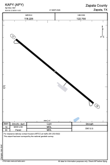
Runways:
| RWY identifier | QFU | Length (ft) | Width (ft) | Surface | LDA (ft) |
| 12 | 129° | 5000 | 60 | ASPH | |
| 30 | 309° | 5000 | 60 | ASPH |
Airport contact information
Address: Zapata United States