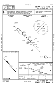


KAOV - Ava Bill Martin Meml
Located in Ava, United States
ICAO - AOV, IATA -
Data provided by AirmateGeneral information
Coordinates: N36°58'19" W92°40'55"
Elevation is 1311 feet MSL.
Magnetic variation is 02° East View others Airports in Missouri
Operational data
Special qualification required
Current time UTC:
Current local time:
Weather at : KBBG - Branson ( 67 km )
METAR: KBBG 132245Z 26005KT 10SM SCT021 BKN110 21/17 A2972
TAF: KBBG 131720Z 1318/1418 16008KT P6SM VCTS BKN035CB TEMPO 1321/1323 4SM TSRA BR OVC025CB FM132300 23008KT 6SM BR BKN050 TEMPO 1323/1324 4SM TSRA BR OVC025CB FM140900 27006KT 4SM BR BKN019 FM141200 29007KT 3SM BR BKN009 FM141300 29008KT 5SM -SHRA BKN006
Communications frequencies: [VIEW]
Runways:
| RWY identifier | QFU | Length (ft) | Width (ft) | Surface | LDA (ft) |
| 13 | 137° | 3634 | 50 | ASPH | |
| 31 | 317° | 3634 | 50 | ASPH |
Airport contact information
Address: Ava United States