


KAOH - Lima Allen County
Located in Lima, United States
ICAO - AOH, IATA - AOH
Data provided by AirmateGeneral information
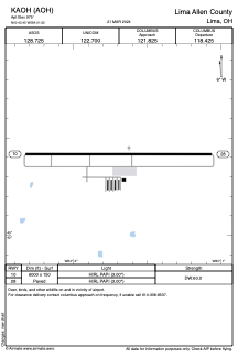
Coordinates: N40°42'27" W84°1'37"
Elevation is 975 feet MSL.
Magnetic variation is -06° East View others Airports in Ohio
Operational data
Special qualification required
Current time UTC:
Current local time:
Weather
METAR: KAOH 291853Z AUTO 21016G31KT 10SM SCT075 25/16 A2992 RMK AO2 PK WND 21031/1844 SLP124 T02500156
Communications frequencies: [VIEW]
Runways:
| RWY identifier | QFU | Length (ft) | Width (ft) | Surface | LDA (ft) |
| 10 | 90° | 6000 | 150 | ASPH | |
| 28 | 270° | 6000 | 150 | ASPH |
Airport contact information
Address: Lima United States
Other aviation service providers
Flight schools

Allen County Regional Airport Authority
Allen County Regional Airport Authority
manager@allencountyairport.com+1(419)227-3225