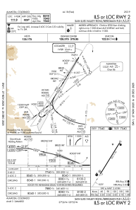
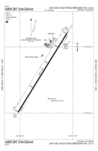


KALS - San Luis Valley Rgnl/Bergman Fld
Located in Alamosa, United States
ICAO - ALS, IATA - ALS
Data provided by AirmateGeneral information
Coordinates: N37°26'6" W105°52'4"
Elevation is 7539 feet MSL.
Magnetic variation is 09° East View others Airports in Colorado
Operational data
Special qualification required
Current time UTC:
Current local time:
Communications frequencies: [VIEW]
Runways:
| RWY identifier | QFU | Length (ft) | Width (ft) | Surface | LDA (ft) |
| 02 | 32° | 8521 | 100 | ASPH | 8519 |
| 20 | 212° | 8521 | 100 | ASPH | 8519 |
Airport contact information
Address: Alamosa United States
