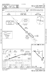
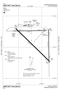


KAIA - Alliance Muni
Located in Alliance, United States
ICAO - AIA, IATA - AIA
Data provided by AirmateGeneral information
Coordinates: N42°3'12" W102°48'14"
Elevation is 3930 feet MSL.
Magnetic variation is 07° East View others Airports in Nebraska
Operational data
Special qualification required
Current time UTC:
Current local time:
Weather
METAR: KAIA 271153Z AUTO 01015G24KT 10SM OVC020 07/04 A2979 RMK AO2 SLP073 70020 T00670044 10083 20050 51015 $
TAF: KAIA 271121Z 2712/2812 36006KT P6SM BKN015 OVC035 FM271300 02012G22KT P6SM OVC012 FM271700 03015G24KT P6SM OVC009 FM272200 03012G20KT P6SM VCSH OVC007
Communications frequencies: [VIEW]
Runways:
| RWY identifier | QFU | Length (ft) | Width (ft) | Surface | LDA (ft) |
| 08 | 89° | 6190 | 75 | ASPH | 6190 |
| 26 | 269° | 6190 | 75 | ASPH | 6200 |
| 12 | 134° | 9203 | 150 | ASPH | 9202 |
| 30 | 314° | 9203 | 150 | ASPH | 9202 |
| 17 | 179° | 6311 | 75 | ASPH | 6311 |
| 35 | 359° | 6311 | 75 | ASPH | 6311 |
Airport contact information
Address: Alliance United States
