


KACT - Waco Rgnl
Located in Waco, United States
ICAO - ACT, IATA - ACT
Data provided by AirmateGeneral information
Coordinates: N31°36'44" W97°13'49"
Elevation is 516 feet MSL.
Magnetic variation is 07° East View others Airports in Texas
Operational data
Special qualification required
Current time UTC:
Current local time:
Weather
METAR: KACT 012351Z 13008KT 8SM BKN035 OVC049 24/23 A2975 RMK AO2 LTG DSNT ALQDS RAB2256E44 SLP068 P0000 60001 T02440228 10278 20239 56016
TAF: KACT 012339Z 0200/0224 15014KT P6SM VCTS BKN035CB FM020200 15014KT P6SM BKN035 FM020600 15015KT P6SM -SHRA VCTS BKN015CB TEMPO 0209/0211 1SM +TSRA OVC015CB FM021300 13009KT 4SM BR BKN008 FM021700 19009KT 4SM BR BKN015 FM021900 19009KT P6SM BKN025 FM022200 17008KT P6SM BKN035
Communications frequencies: [VIEW]
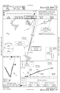
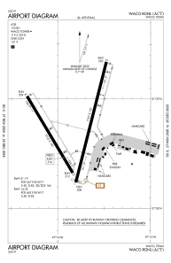
Runways:
| RWY identifier | QFU | Length (ft) | Width (ft) | Surface | LDA (ft) |
| 01 | 14° | 7107 | 150 | ASPH | 7005 |
| 19 | 194° | 7107 | 150 | ASPH | 6605 |
| 14 | 149° | 5103 | 150 | ASPH | 5103 |
| 32 | 329° | 5103 | 150 | ASPH | 5103 |
Airport contact information
Address: Waco United States
