


KACK - Nantucket Meml
Located in Nantucket, United States
ICAO - ACK, IATA - ACK
Data provided by AirmateGeneral information
Coordinates: N41°15'12" W70°3'38"
Elevation is 47 feet MSL.
Magnetic variation is -16° East View others Airports in Massachusetts
Operational data
Special qualification required
Current time UTC:
Current local time:
Weather
METAR: KACK 171553Z 04018G27KT 10SM SCT027 BKN039 OVC048 14/12 A2991 RMK AO2 PK WND 03032/1514 RAE01B18E32 SLP129 P0000 T01440122
TAF: KACK 171515Z 1715/1812 03019G28KT 6SM -RA BR SCT008 OVC035 FM172000 04016G23KT 3SM BR VCSH OVC003
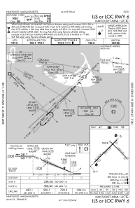
Communications frequencies: [VIEW]
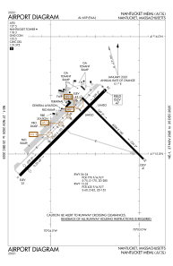
Runways:
| RWY identifier | QFU | Length (ft) | Width (ft) | Surface | LDA (ft) |
| 06 | 45° | 6303 | 150 | ASPH | 5766 |
| 24 | 225° | 6303 | 150 | ASPH | 6303 |
| 15 | 135° | 4500 | 100 | ASPH | 4500 |
| 33 | 315° | 4500 | 100 | ASPH | 4500 |
Airport contact information
Address: Nantucket United States