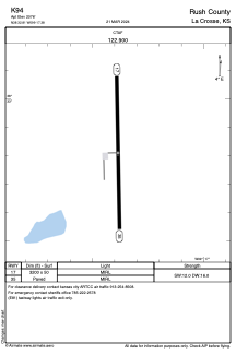


K94 - Rush County
Located in La Crosse, United States
ICAO - K94, IATA -
Data provided by AirmateGeneral information
Coordinates: N38°32'49" W99°17'23"
Elevation is 2076 feet MSL.
View others Airports in Kansas
Operational data
Special qualification required
Current time UTC:
Current local time:
Weather at : KHYS - Hays Rgnl ( 33 km )
METAR: KHYS 152256Z AUTO 04010KT 10SM FEW036 SCT044 OVC070 22/14 A2984 RMK AO2 SLP096 T02170139
TAF: KHYS 152320Z 1600/1624 04009KT P6SM SCT090 FM161100 35007KT P6SM BKN240
Communications frequencies: [VIEW]
Runways:
| RWY identifier | QFU | Length (ft) | Width (ft) | Surface | LDA (ft) |
| 17 | 179° | 3200 | 50 | ASPH | |
| 35 | 359° | 3200 | 50 | ASPH |
Airport contact information
Address: La Crosse United States