


K75 - Osborne Muni
Located in Osborne, United States
ICAO - K75, IATA -
Data provided by AirmateGeneral information
Coordinates: N39°25'60" W98°40'48"
Elevation is 1547 feet MSL.
Magnetic variation is 08° East View others Airports in Kansas
Operational data
Special qualification required
Current time UTC:
Current local time:
Weather at : KRSL - Russell Muni ( 63 km )
METAR: KRSL 190753Z AUTO 08009KT 10SM CLR 17/12 A2991 RMK AO2 SLP113 T01720117
TAF: KRSL 190812Z 1908/2006 08009KT P6SM SKC TEMPO 1908/1910 27024G35KT FM191400 12015KT P6SM SCT100 FM191900 16019G29KT P6SM BKN100 PROB30 1922/2001 VRB30G45KT 2SM TSRA BR BKN020CB FM200100 14013KT P6SM BKN090 PROB30 2001/2003 5SM -SHRA BR BKN030
Communications frequencies: [VIEW]
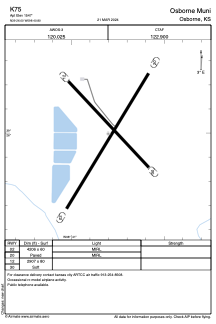
Runways:
| RWY identifier | QFU | Length (ft) | Width (ft) | Surface | LDA (ft) |
| 02 | 0° | 4206 | 60 | ASPH | |
| 20 | 0° | 4206 | 60 | ASPH | |
| 12 | 0° | 2907 | 80 | GRASS | |
| 30 | 0° | 2907 | 80 | GRASS |
Airport contact information
Address: Osborne United States