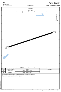


I86 - Perry County
Located in New Lexington, United States
ICAO - I86, IATA -
Data provided by AirmateGeneral information
Coordinates: N39°41'30" W82°11'52"
Elevation is 1051 feet MSL.
Magnetic variation is -07° East View others Airports in Ohio
Operational data
Special qualification required
Current time UTC:
Current local time:
Weather at : KZZV - Zanesville Muni ( 38 km )
METAR: KZZV 301353Z AUTO 00000KT 10SM FEW005 BKN070 OVC085 17/16 A2995 RMK AO2 RAE49 SLP136 P0002 T01720156
TAF: KZZV 301120Z 3012/0112 24006KT 6SM -SHRA SCT030 OVC100 FM301500 26009KT 6SM -SHRA BKN025 OVC080 TEMPO 3015/3018 5SM -TSRA BR BKN025CB FM302100 29006KT P6SM SCT035 FM010500 22004KT P6SM FEW250
Communications frequencies: [VIEW]
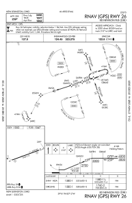
Runways:
| RWY identifier | QFU | Length (ft) | Width (ft) | Surface | LDA (ft) |
| 08 | 72° | 3498 | 75 | ASPH | |
| 26 | 252° | 3498 | 75 | ASPH |
Airport contact information
Address: New Lexington United States