


I44 - Dahio Trotwood
Located in Dayton, United States
ICAO - I44, IATA -
Data provided by AirmateGeneral information
Coordinates: N39°45'54" W84°20'35"
Elevation is 925 feet MSL.
Magnetic variation is -04° East View others Airports in Ohio
Operational data
Special qualification required
Current time UTC:
Current local time:
Weather at : KDAY - James M Cox Dayton Intl ( 19 km )
METAR: KDAY 150656Z 07008KT 5SM -RA BR SCT005 BKN060 OVC080 17/17 A2970 RMK AO2 SLP052 P0001 T01720167
TAF: KDAY 150703Z 1507/1606 07008KT 5SM -RA BR SCT005 BKN060 OVC080 FM151200 05007KT 6SM BR VCSH BKN015 FM151800 02007KT 6SM -SHRA BR VCTS BKN025CB FM152100 02008KT P6SM VCSH BKN050 FM160100 02006KT P6SM VCSH OVC025
Communications frequencies: [VIEW]
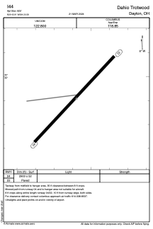
Runways:
| RWY identifier | QFU | Length (ft) | Width (ft) | Surface | LDA (ft) |
| 04 | 43° | 2900 | 52 | ASPH | |
| 22 | 223° | 2900 | 52 | ASPH |
Airport contact information
Address: Dayton United States