


HLSA - Sarir - C4/5Alz
Located in , Libyan Arab Jamahiriya
ICAO - HLSA, IATA -
Data provided by AirmateGeneral information
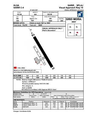
Coordinates: N27°39'39" E22°30'32"
Elevation is 398 feet MSL.
Magnetic variation is 4° East View others Airports in Al Wahat District
Operational data
Special qualification required
Current time UTC:
Current local time:
Weather at : - ( 0 km )
METAR: ROTM 300756Z 21012KT 9999 BKN018 BKN030 28/25 A2972 RMK SLP064 T02840250
Communications frequencies: [VIEW]
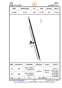
Runways:
| RWY identifier | QFU | Length (ft) | Width (ft) | Surface | LDA (ft) |
| 16 | 167° | 7207 | 136 | ASPH | |
| 34 | 347° | 7207 | 136 | ASPH |
Airport contact information
Address: Libyan Arab Jamahiriya