


HLAB - Abuaisha
Located in Tarhuna, Libyan Arab Jamahiriya
ICAO - , IATA -
Data provided by AirmateGeneral information
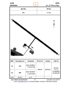
Coordinates: N32°29'42" E13°17'24"
Elevation is 490 feet MSL.
Magnetic variation is 3° East View others Airports in Tripoli District
Operational data
Special qualification required
Current time UTC:
Current local time:
Weather at : HLLM - Tripoli / Mitiga International ( 44 km )
TAF: TAF HLLM 100500Z 1006/1106 33015KT 8000 SCT025 SCT070 PROB40 TEMPO 1006/1012 5000 SHRA BKN020 BKN060 BECMG 1021/1023 VRB02KT
Communications frequencies: [VIEW]
Runways:
| RWY identifier | QFU | Length (ft) | Width (ft) | Surface | LDA (ft) |
| 31 | 309° | 3276 | 80 | ASPH | |
| 13 | 129° | 3276 | 80 | ASPH |
Airport contact information
Address: Tarhuna Libyan Arab Jamahiriya