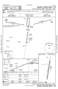
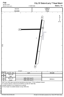


F49 - City Of Slaton/Larry T Neal Meml
Located in Slaton, United States
ICAO - F49, IATA -
Data provided by AirmateGeneral information
Coordinates: N33°29'7" W101°39'42"
Elevation is 3127 feet MSL.
Magnetic variation is 06° East View others Airports in Texas
Operational data
Special qualification required
Current time UTC:
Current local time:
Weather at : KLBB - Lubbock Preston Smith Intl ( 25 km )
METAR: KLBB 040053Z 14018G28KT 10SM FEW018 22/16 A2983 RMK AO2 PK WND 13029/0043 SLP060 T02220161
TAF: KLBB 032320Z 0400/0424 12015KT P6SM BKN100 FM041000 20011KT P6SM SCT050 BKN100 WS020/19045KT FM041500 03015KT P6SM BKN025
Communications frequencies: [VIEW]
Runways:
| RWY identifier | QFU | Length (ft) | Width (ft) | Surface | LDA (ft) |
| 08 | 86° | 1720 | 65 | GRASS | |
| 26 | 266° | 1720 | 65 | GRASS | |
| 18 | 188° | 4244 | 75 | ASPH | |
| 36 | 8° | 4244 | 75 | ASPH |
Airport contact information
Address: Slaton United States