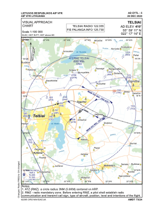
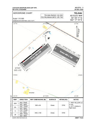


EYTL - Telsiai
Located in Telsiai, Lithuania
ICAO - EYTL, IATA -
Data provided by AirmateGeneral information
Coordinates: N55°59'11" E22°17'16"
Elevation is 410 feet MSL.
Magnetic variation is 7° East View others Airports in Telšiai County
Operational data
Special qualification required
Current time UTC:
Current local time:
Weather at : EYSA - Siauliai/Military/International ( 70 km )
METAR: EYSA 252350Z AUTO 07007KT 9999NDV NSC 13/12 Q1024
TAF: TAF EYSA 252300Z 2600/2609 VRB05KT CAVOK
Communications frequencies: [VIEW]
Runways:
| RWY identifier | QFU | Length (ft) | Width (ft) | Surface | LDA (ft) |
| 05R | 52° | 1903 | 197 | GRASS | |
| 23L | 232° | 1903 | 197 | GRASS | |
| 11 | 119° | 1509 | 328 | GRASS | |
| 29 | 299° | 1509 | 328 | GRASS |
Airport contact information
Address: Telsiai Lithuania