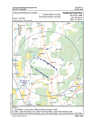
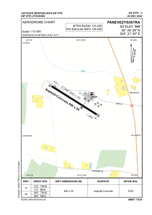


EYPI - Panevezys/Istra
Located in Panevezys, Lithuania
ICAO - EYPI, IATA -
Data provided by AirmateGeneral information
Coordinates: N55°49'39" E24°21'30"
Elevation is 164 feet MSL.
Magnetic variation is 7° East View others Airports in Panevežys County
Operational data
Special qualification required
Current time UTC:
Current local time:
Weather at : EYSA - Siauliai/Military/International ( 61 km )
METAR: EYSA 291550Z 18012KT CAVOK 22/08 Q1026 NOSIG
TAF: TAF EYSA 291400Z 2915/2924 17014KT 9000 NSC BECMG 2917/2919 BKN045
Communications frequencies: [VIEW]
Runways:
| RWY identifier | QFU | Length (ft) | Width (ft) | Surface | LDA (ft) |
| 12 | 122° | 1969 | 66 | CONC+ASPH | |
| 30 | 302° | 1969 | 66 | CONC+ASPH |
Airport contact information
Address: Panevezys Lithuania