


EYKT - Kartena
Located in Klaipeda, Lithuania
ICAO - EYKT, IATA -
Data provided by AirmateGeneral information
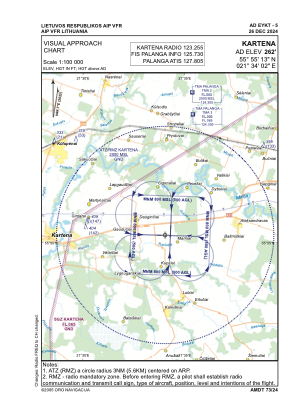
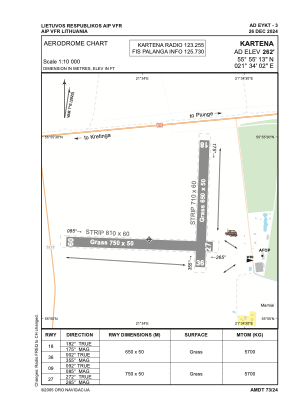
Coordinates: N55°55'13" E21°34'2"
Elevation is 262 feet MSL.
Magnetic variation is 7° East View others Airports in Klaipeda County
Operational data
Special qualification required
Current time UTC:
Current local time:
Weather at : EYPA - Palanga/International ( 30 km )
METAR: EYPA 271020Z 17010KT 150V210 CAVOK 27/02 Q1022
TAF: TAF EYPA 270500Z 2706/2806 12008KT 9000 NSC TEMPO 2709/2717 15018KT
Communications frequencies: [VIEW]
Runways:
| RWY identifier | QFU | Length (ft) | Width (ft) | Surface | LDA (ft) |
| 09 | 92° | 2461 | 164 | GRASS | |
| 27 | 272° | 2461 | 164 | GRASS | |
| 18 | 182° | 2133 | 164 | GRASS | |
| 36 | 2° | 2133 | 164 | GRASS |
Airport contact information
Address: Klaipeda Lithuania