


EYAL - Alytus
Located in Alytus, Lithuania
ICAO - EYAL, IATA -
Data provided by AirmateGeneral information
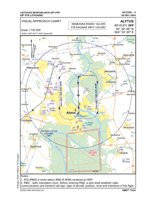
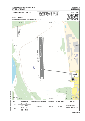
Coordinates: N54°24'46" E24°3'20"
Elevation is 266 feet MSL.
Magnetic variation is 7° East View others Airports in Alytus County
Operational data
Special qualification required
Current time UTC:
Current local time:
Weather at : EYKA - Kaunas/International ( 61 km )
METAR: EYKA 190620Z 24006KT 210V280 9999 FEW072CB 19/11 Q1015
TAF: TAF EYKA 190500Z 1906/2006 VRB05KT 9000 NSC TEMPO 1906/1910 BKN040CB TEMPO 1910/1922 VRB15G25KT 5000 TSRA BKN020CB TEMPO 1922/2004 3000 MIFG BR
Communications frequencies: [VIEW]
Runways:
| RWY identifier | QFU | Length (ft) | Width (ft) | Surface | LDA (ft) |
| 17 | 178° | 2461 | 197 | GRASS | |
| 35 | 358° | 2461 | 197 | GRASS |
Airport contact information
Address: Alytus Lithuania