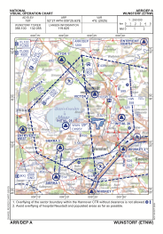


ETNW - Wunstorf
Located in Wunstorf, Germany
ICAO - ETNW, IATA -
Data provided by AirmateGeneral information
Coordinates: N52°27'26" E9°25'38"
Elevation is 187 feet MSL.
Magnetic variation is 3.78° East View others Airports in Lower Saxony
Operational data
Special qualification required
Current time UTC:
Current local time:
Weather
METAR: ETNW 161020Z 12013KT 9999 FEW045 SCT100 BKN280 23/09 Q1006 BLU+BLU+
TAF: TAF ETNW 161005Z 1611/1711 10010KT 9999 NSW SCT300 TEMPO 1611/1613 10015G25KT 9999 NSW SCT100 BKN250 TEMPO 1613/1620 15015G30KT 4000 SHRA SCT020 BKN040CB BECMG 1618/1620 09010KT 9999 NSW BKN100 TEMPO 1620/1624 09012G25KT 5000 -SHRA BKN040 BKN100
Communications frequencies: [VIEW]
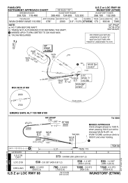
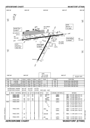
Runways:
| RWY identifier | QFU | Length (ft) | Width (ft) | Surface | LDA (ft) |
| 08 | 82° | 8199 | 148 | CONC | 7385 |
| 26 | 262° | 8199 | 148 | CONC | 7457 |
| 02 | 27° | 5573 | 156 | CONC+ASPH | 5573 |
| 20 | 207° | 5573 | 156 | CONC+ASPH | 5573 |
Airport contact information
Address: Wunstorf Germany
