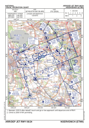
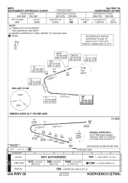
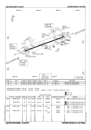


ETNN - Noervenich
Located in Noervenich, Germany
ICAO - ETNN, IATA - QOE
Data provided by AirmateGeneral information
Coordinates: N50°49'52" E6°39'30"
Elevation is 380 feet MSL.
Magnetic variation is 2.78° East View others Airports in North Rhine-Westphalia
Operational data
Special qualification required
Current time UTC:
Current local time:
Weather
METAR: ETNN 271420Z 17011KT 9999 SCT045 SCT070 BKN120 18/06 Q1005 BLU
Communications frequencies: [VIEW]
Runways:
| RWY identifier | QFU | Length (ft) | Width (ft) | Surface | LDA (ft) |
| 06 | 67° | 8010 | 148 | CONC+ASPH | 8010 |
| 24 | 247° | 8010 | 148 | CONC+ASPH | 8010 |
Airport contact information
Address: Noervenich Germany