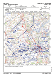
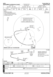
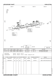


ETNH - Hohn
Located in Hohn, Germany
ICAO - ETNH, IATA -
Data provided by AirmateGeneral information
Coordinates: N54°18'44" E9°32'17"
Elevation is 39 feet MSL.
Magnetic variation is 3.88° East View others Airports in Schleswig-Holstein
Operational data
Special qualification required
Current time UTC:
Current local time:
Weather
METAR: ETNH 171420Z AUTO 06018KT //// // ////// 22/10 Q1010 ///
TAF: TAF ETNH 170700Z 1708/1717 06012KT 9999 NSW SCT120 TEMPO 1711/1717 08015G25KT 9999 NSW SCT120
Communications frequencies: [VIEW]
Runways:
| RWY identifier | QFU | Length (ft) | Width (ft) | Surface | LDA (ft) |
| 08 | 79° | 8004 | 98 | CONC+ASPH | 8004 |
| 26 | 259° | 8004 | 98 | CONC+ASPH | 8004 |
Airport contact information
Address: Hohn Germany