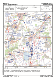
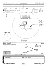
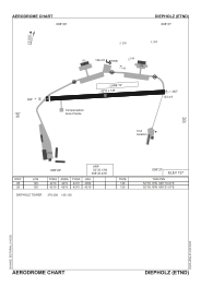


ETND - Diepholz
Located in Diepholz, Germany
ICAO - ETND, IATA -
Data provided by AirmateGeneral information
Coordinates: N52°35'8" E8°20'27"
Elevation is 127 feet MSL.
Magnetic variation is 3.46° East View others Airports in Lower Saxony
Operational data
Special qualification required
Current time UTC:
Current local time:
Weather
METAR: ETND 160820Z 10014KT 9999 BKN210 19/10 Q1005 BLU+
TAF: TAF ETND 160702Z 1608/1617 09010G20KT 9999 NSW BKN250 TEMPO 1612/1617 15010G20KT 4000 SHRA SCT020 BKN040CB PROB30 1612/1617 15015G25KT 2000 TSRA BKN020CB
Communications frequencies: [VIEW]
Runways:
| RWY identifier | QFU | Length (ft) | Width (ft) | Surface | LDA (ft) |
| 08 | 85° | 4210 | 148 | ASPH | 4090 |
| 26 | 265° | 4210 | 148 | ASPH | 4210 |
Airport contact information
Address: Diepholz Germany