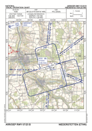
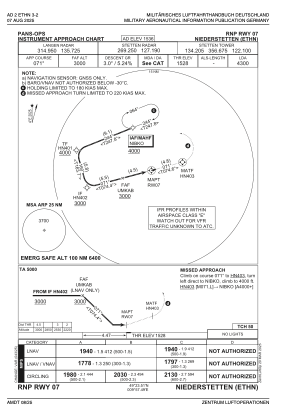
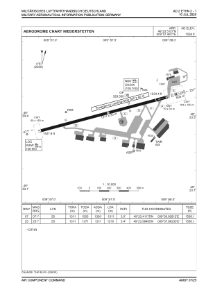


ETHN - Niederstetten
Located in Niederstetten, Germany
ICAO - ETHN, IATA -
Data provided by AirmateGeneral information
Coordinates: N49°23'31" E9°57'29"
Elevation is 1536 feet MSL.
Magnetic variation is 3.65° East View others Airports in Baden-Württemberg
Operational data
Special qualification required
Current time UTC:
Current local time:
Weather
METAR: ETHN 280420Z 14007KT 9999 FEW110 BKN140 10/02 Q1009 BLU
Communications frequencies: [VIEW]
Runways:
| RWY identifier | QFU | Length (ft) | Width (ft) | Surface | LDA (ft) |
| 07 | 75° | 4300 | 98 | ASPH | 4300 |
| 25 | 255° | 4300 | 98 | ASPH | 3969 |
Airport contact information
Address: Niederstetten Germany
Other aviation service providers
Aviation club (not for profit)

Bundeswehr-Sportfluggruppe Niederstetten
Bundeswehr-Sportfluggruppe Niederstetten
bwsfg@flugplatz-ethn.de+497932990025